Showing posts with label natural wonders. Show all posts

Monday, June 6, 2011

A Walk in the Forest on Whidbey Island

IMG_3599 Woodpecker Tree

Back in April I visited my college friend David and his wife Victoria. They live on Whidbey Island, a quick ferry ride north of Seattle. One afternoon during our magical weekend, we took a brief hike in the forest...

IMG_3574 Whidbey forest

...where the air is moist and the moss grows lush.

IMG_3591 moss

The undergrowth is a study in organic design.

IMG_3579 Whidbey forest undergrowth

We had to watch that we didn't step on anyone...

IMG_3578 banana slug
Banana slug (Genus Ariolimax)

...and that no one might step on us.

IMG_3600 woodpecker tree

I had never seen so many varieties of fungi in less than an hour. 

IMG_3594 tree fungus


IMG_3585 black fungus
Update: possibly Bulgaria inquinans
I could not identify one of them...

IMG_3613 fallen tree fungus

... beyond the kingdom of Fungi.

IMG_3618 fungus on felled tree

IMG_3644 tree fungus

Then I saw a mushroom similar to one that my buddy Ken-ichi identified for me last January. Hopefully Ken-ichi, impressive naturalist and co-founder/developer of iNaturalist.org, will confirm that this is of the genus Agaricus.

IMG_3607 fungus


I recognized the morel mushroom from back in the days when I could eat mushrooms without getting a migraine headache.

Morel mushroom (Genus Morchella)

I have never eaten a salmonberry, but I bet it's delicious.

Salmonberry (Rubus spectabilis

Maybe I have to return in the autumn so that I could taste them.
Enhanced by Zemanta

Tuesday, January 25, 2011

Maelstrom in Saltstraumen

IMG_4460 Saltstraumen inflatable boats


Can you imagine what 13 billion cubic feet of water rushing through an impossibly narrow, 500-foot-wide channel would look like? I couldn’t fathom it, but I was about to find out.

During our family vacation on the Hurtigruten Cruise in Norway, we signed up for the “Saltstraumen Safari” near the city of Bodø. This excursion promised to take us to Saltstraumen, the sound that connects the Saltfjord on the west and the much larger Skjerstadfjord on the east. When the tide tries to fill the Skjerstadfjord, up to 400 million cubic meters of seawater surges through the strait that is only 3 kilometers long and 150 meters wide.

View Norway in a larger map (use buttons on top left to zoom in or out)

Our guide carefully checked to make sure we were all properly dressed in our fashion-forward waterproof gear and helped us into the inflatable rubber raft.

IMG_4466 Saltstraumen guide

To the passengers’ squealing delight, our boat driver opened up the engine full throttle as soon as we cleared the speed limit zone near the docks.

On the Norwegian Sea side of the buoys, the water was still quite calm...

IMG_4465 Saltstraumen buoys

...but minutes later, we saw that the rock formations along the banks of the fjord bore clues to their turbulent past.


IMG_4455 saltstraumen scenery

IMG_4454 Saltstraumen scenery

As the channel narrowed, the teal blue water became more restless.

IMG_4472 Saltstraumen blue water

Four times daily, the current can gain speeds up to 22 knots (~40 km/hr or ~25 mph), making this the strongest tidal current in the world.

IMG_4490 Saltstraumen current

The topography creates powerful whirlpools also called Maelstroms.


IMG_4487 Saltstraumen maelstrom

We passed through when the current was turning and the water was deemed "navigable". During the peak, the vortices of the whirlpools can reach 10 meters (~30 ft) in diameter and 5 meters (~15 ft) in depth. The force of these maelstroms are capable of eroding holes in the rock bed that are over 40 meters (~130 ft) deep.

We all gasped when our guide told us that extreme scuba diving is a popular sport here.


It seemed contradictory to see the bucolic scenery along the banks, with hikers enjoying the delicate wildflowers and sidestepping roosting waterfowl.

IMG_4498 Saltstraumen scenery

I was actively concerned for the safety of this black cow who looked like she could loose her footing on the slippery rocks at any moment.


IMG_4500 cow at Saltstraumen

We saw many fishing boats with motors fit enough to get them out of most any maelstrom jams.

IMG_4513 Saltstraumen fishing boat

I know nothing of fishing but it looks like this boat is equipped with every kind of fishing rod imaginable, or are they backup rods in case they loose a battle in the vortex?


IMG_4514 Saltstraumen fishermen

We even saw one angler catch a fish, but they deemed it too small and tossed it back into the maelstrom. Anglers most commonly catch saithe and cod, but they can also expect to catch catfish, rose fish, trout, herring and halibut. Coalfish is the specialty of this area.

BTW, if you look closely, you can see that this small boat is powered by a 400 horsepower engine (!).


IMG_4515 Saltstraumen fishermen

Then it was time to jet back because the tide was gaining strength.

IMG_4493 Saltstraumen inflatable boat

***

UPDATE: Thanks to Cuban in London, I have found the riveting short story by Edgar Allan Poe "A Descent into the Maelstrom" (1841). Here is an excerpt:

In a few minutes more, there came over the scene another radical alteration. The general surface grew somewhat more smooth, and the whirlpools, one by one, disappeared, while prodigious streaks of foam became apparent where none had been seen before. These streaks, at length, spreading out to a great distance, and entering into combination, took unto themselves the gyratory motion of the subsided vortices, and seemed to form the germ of another more vast. Suddenly --very suddenly --this assumed a distinct and definite existence, in a circle of more than half a mile in diameter. The edge of the whirl was represented by a broad belt of gleaming spray; but no particle of this slipped into the mouth of the terrific funnel, whose interior, as far as the eye could fathom it, was a smooth, shining, and jet-black wall of water, inclined to the horizon at an angle of some forty-five degrees, speeding dizzily round and round with a swaying and sweltering motion, and sending forth to the winds an appalling voice, half shriek, half roar, such as not even the mighty cataract of Niagara ever lifts up in its agony to Heaven.

The full story is here.
***

UPDATE: November 4, 2014.

One of the photos in this Flickr set was posted by tahoe_miner_174  on reddit, which inspired a spirited geological discussion here, It included a depiction, by mjackl, of the four major deformation events:


***

I will close with two videos. The first gives a brief look at the maelstrom in action.


This second video was taken by some brave divers.


Thursday, January 13, 2011

The North Cape in the Land of the Midnight Sun


IMG_4899 Nordkapp


After our brief stop at the Sami trading post, we re-boarded the bus to reach the famous headland on the island of Magerøya named the North Cape of Norway.

English Explorer  Richard Chancellor named this point in 1553 when he passed the cape during his search for the Northeast PassageNordkapp is the Norwegianized form of the English name.

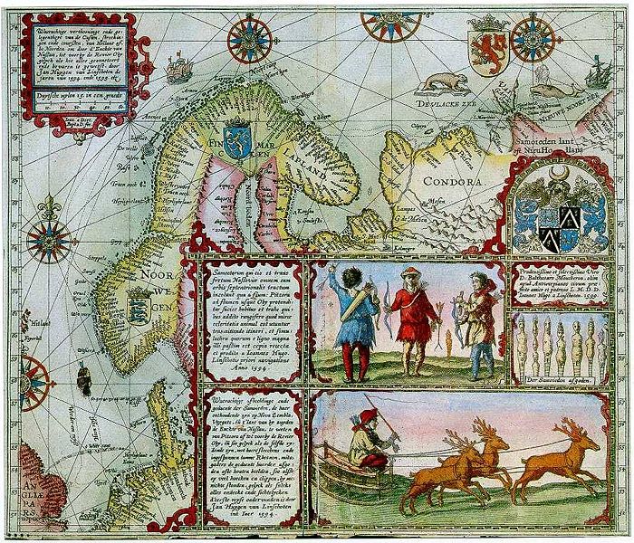
The North Cape is the point where the Norwegian Sea, the Atlantic Ocean, the Arctic Ocean, and the Barents Sea all converge. The Barents Sea was named after Dutch explorer and cartographer Willem Barentsz. This enchanting depiction is from the journal of fellow cartographer Jan Huyghens van Linschoten who joined Barentsz during his first two attempts at finding the Northeast Passage in 1594.

Source: Wikipedia
When I was in elementary school in Amsterdam, I learned about Barentsz’s tragic death at sea. I even had a jigsaw puzzle illustrating his quest. A nice summary of Barentsz's adventures can be found here at the website with the very intelligent name godutch.com. 

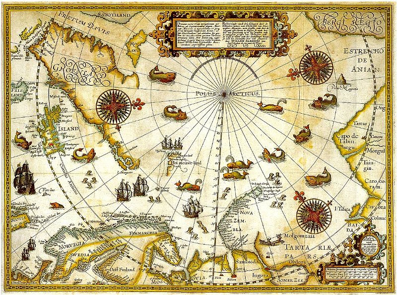
Barentsz remarkable map of his third attempt in 1597; it was published two years later. 


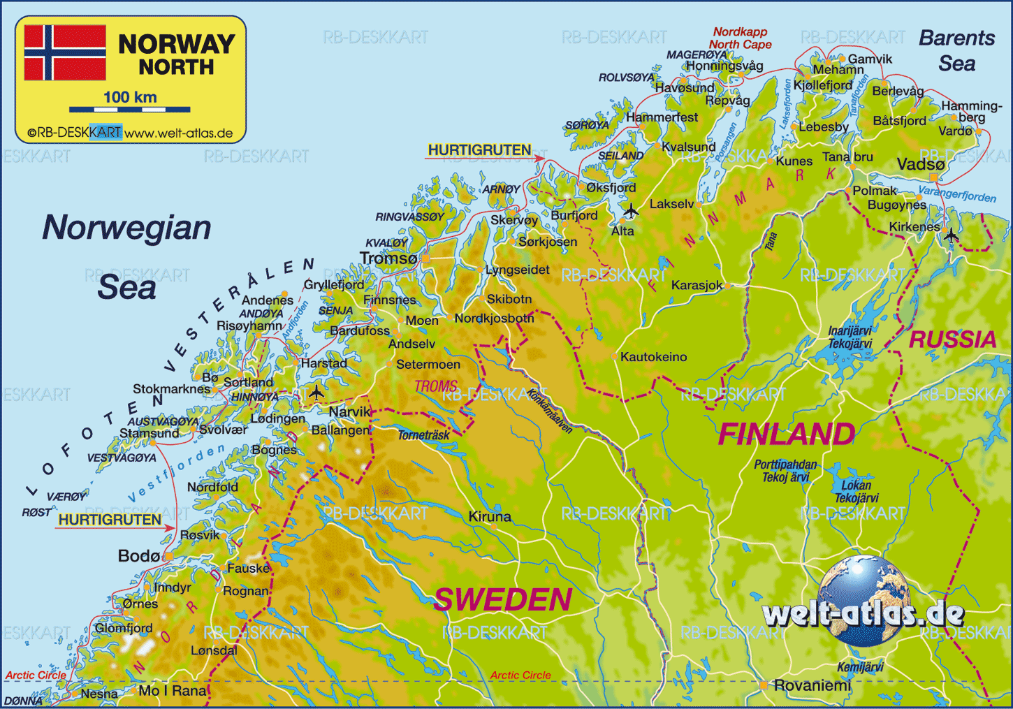
This modern, less fanciful, map shows the red Hurtigruten route we sailed on the “MS Midnatsol”. The North Cape is labeled, also in red, at the top of this map.

The North Cape is at latitude 71 degree, 10 minutes, and 21 seconds, just over a couple of thousand kilometers south of the North Pole. To give a frame of reference,  San Francisco is at latitude 38 north and London is at 51.


IMG_4878 Nordkapp 71 degrees 10 minutes 21 seconds

The North Cape's headland overlooks a barren, yet picturesque landscape. On this grey day, it was difficult to differentiate between the sky and the horizon.

IMG_4921 North Cape

The steep cliff rises 307 meters ( 1,007 feet) above the sea...

IMG_4891 Nordkapp

Today’s most iconic image of the North Cape is the globe that was built in 1978.

IMG_4915 Nordkapp


IMG_4898 Nordkapp

Daring explorers have scaled the walls of cliffs of the North Cape over the years. This spire commemorates the visit of King Oscar II of Sweden and Norway in 1873. 

IMG_4910 North Cape King Oscar II spire


In 1956, a road was built to give easier access to this famous landmark. The North Cape Hall houses the elaborate tourist center...

DSC07828 Nordkapp

...which features full-scale dioramas of scenes of the journey and arrival of King Oscar II.  A Thai temple and shrine honor Thailand's King Chulalongkorn's visit in 1907.

IMG_4886 nordkapp shrine thai kingDSC07835 Nordkapp shrine

The ecumenical chapel  St. Johannes Kapell...

IMG_4888 st johannes kapell

...has a beautiful mosaic entry shaped like the bow of a ship.

IMG_4887 nordkapp kappel ship's bow mosaic

...which is an altar with an opalescent mosaic on the inside.

DSC07834 Nordkapp Chapel altar

A full bar, with its unique architecture and furniture that blends into the environment, allows you to take in the view while sheltered from the elements. 

DSC07836 Nordkapp restaurant ceiling

We had soup and an open-face sandwich in the nautically-decorated cafeteria.

DSC07831 Nordkapp from cafe

We had time to briefly visit the Children of the Earth Monument...

IMG_4903 North Cape Children of the Earth monument


...before our bus ride back to our ship.

IMG_4588 Midnatsol


“Midnatsol” is the word for “midnight sun” in Norwegian. The midnight sun can be seen from the North Cape between May 14 and July 29. We were at the Cape on August 2nd, so technically the sun did set, but I certainly did not witness it. I remember waking up in the middle of the night curiously looking out our porthole. Though this was taken a few hours earlier, it looked very similar at three in the morning. 


IMG_4946 Midnatsol porthole

I took this picture from the ships deck the night before, when we were still at the 70th parallel north.

IMG_4739 from the Midnatsol

After seeing the beauty of the sun’s light in this part of the world, I can understand why the midnight sun has been a major inspiration for literature, music, and countless paintings.
Enhanced by Zemanta

Related Posts Plugin for WordPress, Blogger...
Bookmark and Share